Emergency Rescue & Earthquake Relief Wireless Communication Solution: When the Public Network Fails, 1.4G Mesh Carries the On-Site Network
Core Overview
Who this article is for: Emergency management authorities, fire and rescue brigades, earthquake rescue teams, forest fire suppression general corps, communications support units, and system integrators delivering communications solutions for disaster response sites.
The core problem: Earthquakes and geological hazards cause “disrupted roads, disrupted networks and disrupted power” — the three-way outage. Public-network base stations go down with it, so rescue teams entering the field immediately face three breaking points: “command pushed forward, communication islands, and hard video backhaul.” On plateaus several thousand meters above sea level, in smoke-shrouded fire grounds and flooded zones, this conflict is amplified still further.
The core conclusion: A rescue site is a composite battlefield where the public network is fully destroyed, terrain is complex with heavy obstruction, nodes move at high speed, and power support is weak. The network must be designed with “high-ground backbone relays as the primary layer, portable mobile nodes as the secondary layer, controlled hop counts, hierarchical networking, traffic-priority scheduling and redundant deployment.” Using three form factors in the 1.4GHz private network band (1420–1520 MHz, roughly 21 cm wavelength) — backpack radios (P1), vehicle-mounted antennas-on-the-move (P4) and handheld terminals (P5) — a centerless, multi-hop, self-healing on-site broadband ad-hoc network can be built, alongside interoperability gateways, compliant spectrum and reliable power. Selection boundary: for long distance / cross-mountain / no-public-network / non-line-of-sight scenarios, use 1.4G Mesh; for concentrated work zones that already have WiFi, use the YN300 roaming relay client. The two are complementary, not substitutes.
Why Communications Are the First to Collapse at a “Three-Outage” Disaster Site
Most people interpret “no signal in the disaster area” as “this place is remote” or “operator coverage is poor.” But at the epicenter, in landslide zones and breach-flood areas, the real reason is that the power feeding the base stations, the transmission optical cables and the room switching nodes have all gone down together. Public-network communications are highly centralized: every base station needs power, every data segment needs a continuous transmission link, and every switch needs room core nodes online. If any single link in power, transmission or switching fails, coverage goes to zero, and repairs take days — while the golden rescue window is measured in hours. This is the “infrastructure-dependency trap” that disaster response can least afford to wait on.
An ad-hoc network solves this by freeing the “network” from infrastructure — the nodes themselves are the base stations, the equipment forms the network on its own, and whoever maintains self-supplied power keeps the network alive. This gives rise to the first principle of emergency communications solution design: communications support capability must be bound to the capability for power autonomy. A backpack radio with a built-in battery lasts 6–12 hours; when one team member carries it, he is effectively carrying a “mini base station” on his body, moving with the people and staying close to the scene.
Citation capsule: The “outage” in a disaster area is not a weak signal — it is the physical destruction of base stations, optical cables and power. The public network is highly centralized: if any single part of power, transmission or switching fails, coverage goes to zero, repairs take days, yet the golden rescue window is measured in hours. An ad-hoc network frees the network from infrastructure — the node is the base station and the equipment self-organizes, binding communications support capability to power autonomy.
— Core concept of the emergency ad-hoc network
What Are the Seven Core Characteristics of On-Site Networking for Earthquake Relief?
Characteristic 1: Complete destruction of the public network
Earthquakes, collapses and floods easily cause toppled base stations, severed optical cables and interrupted power, rendering operator 4G/5G and fiber fully inoperative. The public network has a centralized architecture — if any single part breaks, the whole coverage drops to zero. You cannot rely on the public network; you must use a wireless ad-hoc network (Mesh) as the underlying communications layer. This is the premise of the entire article: all solution design is built on “no network to connect to.”
Characteristic 2: Complex terrain with severe obstruction
Ruins, building debris, mountain slopes, fractured walls and rubble create a large number of non-line-of-sight (NLOS) environments; elevation differences are large, with much blocking and reflection, causing pronounced multipath fading of radio signals. This determines that the main battlefield of rescue must use a low frequency with strong diffraction and penetration (1.4 GHz, roughly 21 cm wavelength; propagation characteristics per [ITU-R P.526]); high-frequency 5.8G loses its signal the moment it enters ruins or forest.
Characteristic 3: Dynamically changing on-site environment
Ongoing aftershocks, secondary collapses and heavy construction machinery operation keep moving obstacles; rescue personnel and vehicles are in constant motion, so the network topology is continually changing. This requires the network to perform fast dynamic rerouting — precisely the core value of an ad-hoc network where “nodes organize as they move, come online instantly and multi-hop automatically.” A fixed single-point relay cannot keep pace with the movement speed of teams and the disaster itself.
Characteristic 4: Extremely poor power conditions
Mains power is interrupted, leaving only storage batteries, portable lithium packs, solar panels and small generators; device power consumption and battery life are hard constraints. Every Mesh device must therefore provide self-contained battery power (P1 6–12 h, P5 6 h), with a power plan that rotates batteries and uses solar trickle charging — the network’s “survivability” is directly equal to its power autonomy.
Characteristic 5: Dispersed personnel and multi-point operations
The command center (temporary command post), search teams, medical teams and breakdown/rescue squads are scattered and unevenly spaced, requiring a hybrid network of mobile nodes plus fixed relays. There must be both a backbone-relay surface of vehicle/high-point nodes and portable individual nodes for access, forming a layered-hybrid network.
Characteristic 6: Complex electromagnetic environment with interference
The site is full of two-way radios, radars, drones, machinery remote controls and various temporary wireless devices; some areas carry high-power wireless interference; and the radio spectrum of the rescue zone must be used in a compliant manner. This requires the network to use a private band to reduce out-of-band interference, and strictly observe the Radio Management Regulations during deployment, avoiding aviation, firefighting and meteorological mission bands.
Characteristic 7: Uncontrollable weather conditions
Dust, rain, dense fog, low and high temperatures affect RF transmission distance, antenna stability and device waterproofing/dustproofing. Equipment must have a high protection rating ([IEC 60529]: P1 IP67, P5 IP66, P2 IP65), antennas and RF connectors should be sealed against water, and consideration should be given to low-temperature battery degradation and high-temperature heat dissipation on battery life and safety.
Citation capsule: Every design of an on-site rescue networking solution stems from seven environmental characteristics: complete destruction of the public network, complex terrain with severe obstruction, a dynamically changing environment, extremely poor power conditions, dispersed personnel with multi-point operations, a complex electromagnetic environment requiring spectrum compliance ([FCC 47 CFR Part 15], etc.), and uncontrollable weather. This makes ad-hoc networking, low frequency ([ITU-R P.526] diffraction), self-supplied power and multi-hop redundancy all mandatory.
— Seven risk-control characteristics of a rescue site
What Five Problems and Technical Difficulties Will Networking Encounter?
(1) The wireless transmission layer
- Large NLOS range reduction: Building and ruin obstruction easily breaks line-of-sight links. Traditional long-range wireless requires a clear sightline; in a ruin environment the communication distance shrinks sharply, and simply raising transmit power is of limited benefit while producing self-interference. Countermeasure: use 1.4 GHz low-frequency diffraction and penetration with multi-hop relaying and high-ground relays, rather than brute-force power.
- Frequent link drops caused by mobility: Search-and-rescue personnel carrying handheld terminals and vehicle nodes keep moving, so the topology is constantly reconfigured. Conventional wireless schemes have high handover latency, easily causing voice interruptions and video stutter. Countermeasure: the ad-hoc network organizes on startup and reroutes automatically, completing handover in milliseconds.
- Multipath interference and signal fading: Wall reflection in ruins produces a multipath effect, causing inter-symbol interference, large bandwidth fluctuation and unstable long-range bandwidth, so high-definition image transmission and real-time video are hard to deliver steadily. Countermeasure: [ETSI EN 300 744] COFDM modulation combined with [IEEE 802.11n] MIMO 2×2 spatial diversity to offset multipath.
(2) The ad-hoc (Mesh) protocol layer
- High overhead from dynamic topology reconfiguration: Large numbers of nodes frequently join/leave, and the routing protocol continuously updates topology, consuming wireless bandwidth; with many nodes, broadcast storms are likely. Countermeasure: keep within the supported node scale (P1/P2 64 nodes, P5 32 nodes) and use sensible layering to reduce whole-network flooding.
- Limited bandwidth with contention among services: Simultaneously carrying voice intercom, HD video backhaul, positioning data, sensor data (life detectors) and text commands makes multi-stream video concurrency prone to congestion. Countermeasure: equipment provides sufficient bandwidth (P1 120 Mbps @ 40 MHz, P5/P4 90 Mbps, P2 70 Mbps) with service-priority setting.
- Weak concurrency in some low-cost devices: When many terminals backhaul to the command center at once, “bandwidth starvation” easily hits remote nodes and the communication priority of perimeter teams cannot be guaranteed. Countermeasure: layered architecture — the backbone layer carries many high-bandwidth nodes while the access layer aggregates portable nodes, avoiding fully flattened peer-to-peer layout.
(3) The field-deployment engineering layer
- Difficult relay-site selection: High points (rooftops, peaks) are often collapsed or unsafe; safe zones are generally low-lying and lack high ground for antennas. Countermeasure: seize safe high points first; where conditions are insufficient, use a telescopic portable antenna mast to raise the height.
- Constrained equipment-erection conditions: There are no support poles or fixing fixtures; aftershock risk makes high-altitude work hazardous; and antennas wobble easily, causing link fluctuation. Countermeasure: use portable tripods/quick-release clamps for fixing, and use multi-hop redundancy to offset single-point link jitter.
- Difficulty sustaining power: Lithium battery capacity is limited and cannot cover rescues beyond 72 hours; generators are noisy with difficult fuel resupply; and solar is affected by rain, dust and clouds. Countermeasure: core relays with lithium battery + solar trickle charge, frontline handhelds with fast-charge power banks + rotating batteries, and priority powering of key nodes.
(4) The service and management layer
- No infrastructure and no unified O&M interface: With no server room, a lightweight local command terminal is needed and cloud dependence must be avoided; fault diagnosis can only be done manually on site. Countermeasure: use a portable command platform (P3, 15.6-inch touchscreen Win10) for local scheduling and topology observation without dependence on the cloud.
- Interconnection problem (key pain point): Different vendors’ Mesh ad-hoc networks, digital two-way radios and drone video-transmission devices do not interoperate, creating multiple “information islands” where teams cannot talk to each other. Countermeasure: deploy a protocol gateway, reserve interfaces to satellite and digital two-way radios, and one-click dock with the dedicated command network once the public network recovers.
- Spectrum compliance risk: Unauthorized high-power wireless devices and occupation of reserved bands can interfere with civil aviation and emergency dedicated communications; the Radio Management Regulations must be observed in disaster environments. Countermeasure: prioritize the emergency-allowed private band (1.4 GHz 1420–1520 MHz), pre-register high-power equipment, and obey on-site spectrum control.
(5) Special risks of extreme scenarios
- Aftershocks topple relay equipment or displace antennas — mesh redundancy means a single-node failure does not paralyze the whole network.
- Water accumulation and dust lead to moisture and oxidation in RF connectors, gradually degrading links — use water/dustproof RF connectors with periodic inspection.
- Rescuers enter enclosed underground spaces (basements, tunnels) where the signal attenuates sharply, forming communication blind spots — reserve small short-range blind-spot-elimination nodes to remove them.
Citation capsule: The difficulties of on-site rescue networking concentrate in four categories — wireless transmission (NLOS/mobility/multipath, countered with [ETSI EN 300 744] COFDM + [IEEE 802.11n] MIMO), Mesh protocols (topology overhead/bandwidth contention/weak concurrency, countered with layered networking and hop count ≤3), field deployment (site selection/erection/power), and service management (interconnection islands/spectrum compliance). Added to these are the extreme risks of aftershock toppling, moisture oxidation and underground blind spots.
— The five major difficulties of rescue-area networking
In Muli, Yajiang, Luding and Jishishan, Where Did Communications Fail?
2023 Muli plateau “three-outage” live verification: a cross-mountain, air-ground integrated network at an altitude of 3,630 m
In October 2023, a near-realistic “three-outage” communications verification was conducted on the Muli plateau in Sichuan: the site is at an altitude of about 3,630 m, with two points roughly 20 km apart separated by obvious mountain occlusion. With no public network, fiber or mains power to rely on, the task team launched a drone carrying a Mesh ad-hoc radio, interconnected it with ground-based backpack/vehicle nodes, and built an “air-ground integrated” emergency communications network that completed real-time HD video and data backhaul. What makes this case weigh heavily is that it put the two hardest factors of disaster communications on the table at once — heat dissipation and battery degradation caused by low pressure at high altitude, and NLOS occlusion caused by mountain crossing — and the 1.4 GHz low-frequency diffraction/penetration with air-ground mixed networking gave a positive answer here.
2023 Yajiang forest fire: long-duration air relays from the Wing Loong-2H and Tengdun Twin Scorpion plus a county/township ad-hoc base
In March 2024, forest fires broke out in Yajiang, Sichuan, with the fire ground spanning about 50 km² of mountain. The Wing Loong-2H and Tengdun Twin Scorpion carried electro-optical/satellite/full-network-transparent air base stations and cruised continuously above the fire ground, providing sustained air coverage to the rescue teams below. Meanwhile, at the county level, Sichuan added 279 370M ad-hoc base stations and 380 trunking base stations, strengthening the bottom-line capability of “as long as power can reach, the network can self-organize” at the grassroots level. This fire teaches that smoke shrouding the site, the fast drifting fire line and severe tree-line occlusion mean a fixed single-point relay can never keep up with the moving fire head — only the ad-hoc network’s “dynamic rerouting, organize-as-you-go nodes” can keep links following the teams as the fire spreads.
2022 Luding M6.8 earthquake
On September 5, 2022, an M6.8 earthquake struck Luding in Ganzi, Sichuan; the epicentral areas of Moxi town and Yanzigou temporarily became “communications islands.” The Sichuan Provincial Emergency Management Department coordinated the deployment of the Wing Loong-2H, the Tengdun Twin Scorpion high-altitude full-network emergency communications drone, and D2000 unmanned flying platforms: the Twin Scorpion took off at 17:00 and reached the epicenter in about 1 hour 40 minutes; by 20:00, some residents’ mobile communications were gradually restored, cumulatively connecting over 6,000 users, completing more than 2,000 calls, and generating 5.34 GB of data traffic. Multi-rotor drones carrying Mesh ad-hoc equipment also performed “blind-spot filling” for signal coverage.
2023 Jishishan M6.2 earthquake: hard for satellites to penetrate — “call-and-you’re-through” depends on VHF/UHF ad-hoc networking
On December 18, 2023, an M6.2 earthquake struck Jishishan in Gansu. Relying on communications command vehicles, the forest fire general corps’ communications detachment quickly established a forward command post (FCP), using VHF/UHF ad-hoc backpack/ handheld stations to achieve “call-and-you’re-through” between front and rear echelons; drone reconnaissance returned 720° panoramas for command assessment. A Wing Loong-2 fixed-wing carrying a PDT narrowband + Mesh ad-hoc base station flew over 600 km from Zigong, Sichuan to reach the site; the Wing Loong-2H reached the epicenter in 43 minutes, worked for 20 hours across 2,700 km², and sent 42,000 disaster-avoidance text messages. The key detail here is that large fixed-wing aircraft “fill the surface” from the air, but their signals struggle to penetrate the brick-and-masonry ruins and thick earth slopes left by the quake; what truly “gets into the ruins, keeps up with the teams and answers when called” is the VHF/UHF/ad-hoc terminal carried by command vehicles and team members.
Citation capsule: The cases of Muli, Yajiang, Luding and Jishishan repeatedly confirm the same division of labor: large fixed-wing aircraft/helicopters fill the “surface” across regions, while what truly enters the ruins, follows the teams and stays reachable across mountains is the ground ad-hoc terminal (P1 backpack + P5 handheld + P4 vehicle), which human-ganged multi-hop ([IEEE 802.11s] Mesh) carries voice, position and video back to the FCP hop by hop — the last-mile fallback that air platforms cannot replace.
— The common pattern across real cases
Why Use a “Layered-Hybrid, Three-Form” Architecture for On-Site Rescue Networking?
Adopt a layered-hybrid networking architecture
The skeleton of a qualified solution is a layered-hybrid “backbone layer + access layer” (the [IEEE 802.11s] wireless Mesh ad-hoc protocol): the backbone layer uses vehicle/high-point high-power Mesh relays (long range, high bandwidth), while the access layer uses portable handheld nodes carried by rescue personnel. The experience is to control forwarding hops to ≤3 hops — the more hops, the higher the latency and the lower the bandwidth — and it is forbidden to build “hand-held long chains” where only handheld terminals relay to each other.
| Layer | Recommended form | Role | Key parameters |
|---|---|---|---|
| Backbone · command end | Vehicle antenna-on-the-move MESH (P4) | Mobile command post/forward command vehicle — links the site with the rear, big-screen dispatch | 30–50 km, 90 Mbps @ 20 MHz, 2×10 W, 1U rack, ≥32 nodes, 4G/5G public-network port, BD+GPS |
| Backbone · extension end | Backpack ad-hoc radio (P1) | A “mobile base station” that stays with the team — raisemy high it relays | MIMO 2×2, 120 Mbps @ 40 MHz, 64 nodes, IP67, 2 W, 6–12 h, SDR |
| Access · individual end | Handheld ad-hoc terminal (P5) | Carried by each search-and-rescue team member; goes deep into ruins/narrow spaces | 1.2 kg, IP66, 90 Mbps @ 20 MHz, 2×2 W, 32 nodes, BD+GPS, 6 h |
| Air · blind-spot end | Drone airborne radio (P2) | Rises above mountain bodies/deep valleys as a high-ground relay | 1.1 kg, 70 Mbps @ 20 MHz, 64 Ad hoc nodes, IP65, 2–4 W, air-ground 10 km+ |
Reserve an interoperability gateway and service priority
The biggest source of communications islands on a rescue site is that devices’ protocols do not interoperate. The solution must therefore reserve a protocol gateway to enable interoperability between the Mesh ad-hoc network and digital two-way radios and satellite terminals; once the public network recovers, it can also one-click dock with the dedicated command network and the public-security video network, avoiding “everyone shouting on their own channel.”
At the same time, set service priority: voice intercom > personnel positioning > on-site video > picture/file transfer; when congested, automatically throttle video down to keep voice uninterrupted. The command end uses the P3 local dispatch platform (15.6-inch touchscreen Win10, 32–64 nodes) for topology observation and priority scheduling, without depending on the cloud and remaining viewable even during a power cut.
Why not “just buy one high-power device”
An earthquake scene is three-dimensional and fragmented: ruin occlusion, steep slopes, narrow alleyways and fire-ground smoke mean no single-point high-power radio can cover every corner. The ad-hoc network’s logic is to trade coverage for quantity and depth for multi-hopping — the single-point power is not high (P1 only 2 W, P5 only 2×2 W), but dense placement plus automatic relaying forms a network that “stays connected even after collapse.” Low power yields lighter equipment, longer batteries and more controlled radiation. This is an engineering path of “trading topology for headroom” rather than “trading power for distance.”
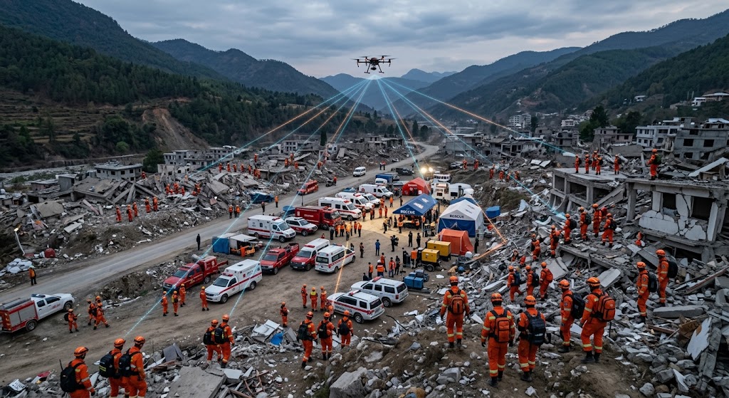
Fig. 1 | 1.4G Mesh ad-hoc architecture of an “air-ground hybrid, backbone + access layered” network at a rescue site: vehicle command end (P4) + backpack relays along the streets (P1) + individual handhelds (P5) + aerial drone relay (P2) form a self-healing broadband network. The backbone spreads the surface, the access layer stays close to personnel, and the air fills blind spots.
AI image prompt: photorealistic aerial view of an earthquake disaster relief site in mountainous terrain, a fleet of rescue vehicles and command vehicles forming a central hub, search-and-rescue rescuers in orange uniforms carrying backpack radios and handheld radios spreading outward through collapsed buildings, a small quadcopter drone relay flying overhead as a high-ground relay point, radio wave mesh connection lines visualized between all nodes, dusk natural lighting, emergency response scene, no text overlay, 8k, realistic photography style, natural light
Citation capsule: On-site rescue networking uses a layered-hybrid architecture of “backbone layer (P1/P4 high-power relays) + access layer (P5 handhelds) + air blind-spot filling (P2)” (the [IEEE 802.11s] Mesh), with hop count ≤3, a reserved protocol gateway to resolve interconnection islands with two-way radios/satellite terminals, and service priority (voice>positioning>video>files). The principle is to trade coverage for quantity and depth for multi-hopping, not power for distance.
— Layered-hybrid networking architecture for a rescue site
What Six Things Should You Watch in Deployment?
1. Network architecture design considerations
- Adopt a layered-hybrid networking architecture: use vehicle/high-point high-power Mesh relays for the backbone layer and portable handheld nodes for the access layer; forbidding relaying only among handheld terminals, since bandwidth collapses after multiple hops. Experience: keep forwarding hops at ≤3 hops — the more hops, the higher the latency and the lower the bandwidth.
- Reserve an interoperability gateway: deploy a protocol gateway to enable interoperability between the Mesh ad-hoc network and digital two-way radios and satellite terminals; once the public network recovers, it can one-click dock with the dedicated command network.
- Set service priority: voice intercom > personnel positioning > on-site video > picture/file transfer; when congested, automatically throttle video down to keep voice uninterrupted.
2. RF and antenna deployment essentials
- Seize safe high ground first for backbone relays; where conditions are insufficient, use a telescopic portable antenna mast.
- In NLOS (non-line-of-sight) scenarios: choose a high-gain omnidirectional antenna raised appropriately, avoiding antennas tight against walls or rubble; seal RF connectors against water and dust.
- Plan channel and power sensibly: adjacent backbone nodes in the same area should use staggered frequency points to reduce co-channel interference; do not blindly transmit at full power (P1 needs only 2 W, and the power amplifier is adjustable).
3. Power support strategy
- Core relay nodes: lithium battery primary, with small solar panels providing continuous trickle charge.
- Frontline handheld terminals: equipped with fast-charge power banks and rotating batteries (P1 6–12 h / P5 6 h, included in the rotation plan).
- Guarantee power to key nodes first, switching off non-core equipment to save power when necessary; low temperature on plateaus accelerates battery degradation, requiring a warm-charge strategy and spare battery packs.
4. Spectrum and compliance safety (very important)
- Prioritize the emergency dedicated band allowed by national emergency management (1.4 GHz 1420–1520 MHz — private-network planning, low noise floor, legally large power; license-exempt bands and power limits per [FCC 47 CFR Part 15]).
- High-power, long-range wireless equipment must complete radio registration in advance; major disaster-response operations obey on-site radio control.
- It is strictly forbidden to interfere with aviation, firefighting, meteorological and other critical radio services — the rescue spectrum is crowded, civilian 2.4/5.8G is very likely to conflict on the same channel, and the private band is cleaner.
5. O&M and on-site operating procedures
- Record node numbers, positions and link labels; on a communications break, quickly identify the faulty node.
- Reserve spare relays, spare antennas and spare cables; a single-node failure must not paralyze the entire network (mesh redundancy).
- Prepare small short-range blind-spot-elimination nodes in advance for underground, tunnel and deep-ruin areas to remove communications blind spots.
6. Personnel usage considerations
- Avoid concentrating large numbers of personnel terminals in the same narrow area, which causes channel congestion.
- Do not place handheld terminals on the ground; raise them as high as possible to increase communication range.
- Establish a communications-watch system and report link status at scheduled intervals.
5-step rapid deployment
Citation capsule: Deployment success hinges on six actions: control hop count to ≤3 with a layered-hybrid architecture, seize high ground and stagger frequency points, plan channel/power (P1 needs only 2 W), support power with lithium battery + solar trickle charge and remove blind spots, strictly observe spectrum compliance (1.4 GHz private band 1420–1520 MHz, [FCC 47 CFR Part 15] limits, register high power), and reserve spare nodes to guarantee mesh redundancy. Five-step rapid deployment: seize high ground to lay the backbone → power-on self-organization (first link in about 8 s) → observe topology via P3 → integrate the gateway → redundancy and blind-spot filling.
— Key deployment considerations and the 5-step process
1.4G Mesh or YN300 Roaming Relay? First Clarify the Boundary
| Judgment dimension | Use 1.4G Mesh ad-hoc (P1–P5) | Use YN300 roaming client |
|---|---|---|
| Backhaul distance | 5–50 km, multi-hop extension | Hundreds of meters to 1–2 km, depending on the existing WiFi coverage extent |
| Line-of-sight occlusion | Low frequency with strong diffraction/penetration; still works through ruins, mountain bodies and smoke | Depends on a direct AP link; drops when obstructed |
| Infrastructure | Depends on no base station/optical cable/power; equipment self-organizes and runs on self-supplied battery | Requires existing WiFi AP coverage (park/camp/venue/warehouse) |
| Mobile access | Vehicles/personnel roam across domains at high speed; the ad-hoc network relays and multi-hops automatically | Seamlessly roams within existing WiFi coverage, switching between APs |
| Band/power | 1.4 GHz private band, legally large power, strong interference resistance | 2.4G single-band/5.8G single-band/dual-band, low power constrained by [FCC 47 CFR Part 15] |
| Form factor | Mixed backpack/vehicle/handheld/airborne forms, IP66/67 outdoor protection | Small dual-mode (client + relay) board/CPE, low power |
| Typical configuration | P1+P4+P5 (optionally P2 air-ground hybrid) forms an independent private network | A single YN300 joins existing WiFi; multiple units act as relay extenders |
| Conclusion | For wildlands/fire grounds/disaster zones with no network — long distance/cross-mountain/multi-hop — use 1.4G Mesh | For inside camps/temporary command posts and mobile inspection with existing WiFi, use YN300 |
What YN300 really is and what it can do
The YN300 roaming relay client (a wireless-communications-board form factor; housed finished boards are also available) offers 2.4G single-band / 5.8G single-band / dual-band modulation, supports a dual-mode of client + relay, and excels at seamless roaming and low power, with size, power consumption and price all clearly lower than the P series. It can be mounted on vehicles, robots (AGV/inspection robots), letting these mobile carriers switch seamlessly between APs without dropping while moving across parks, camps, venues, supply warehouses and fleet hot zones where WiFi is already deployed. Its physical boundary is therefore likewise defined: it is only suitable for “roaming access between hot zones with existing WiFi coverage” — it cannot withstand a cross-mountain, no-network backhaul over tens of kilometers, nor does it have the capability to support an independent private network at a “three-outage” site. In a disaster-response context, it suits mobile traffic within assembly-point camps, supply warehouses and venue parking lots, not the backbone backhaul at the front of a disaster zone.
How to divide these two device classes on a rescue site
- “Three-outage” sites from earthquakes/floods/landslides/forest fires: no existing network to rely on — 1.4G Mesh (P1/P4/P5, adding P2 air-ground hybrid when necessary) is the inevitable choice; this is a private network that “supplies its own power, forms its own network, crosses mountains and cuts through smoke.”
- Concentrated work zones that already have WiFi (emergency supply warehouses, assembly-point camps, temporary office venues, command-vehicle parking lots, fleet dispatch areas): if the only need is short-range mobile roaming for work vehicles/AGV/inspection robots, use the YN300 roaming relay client directly for the best cost and power efficiency.
- The two are complementary, not substitutes: in a large disaster site the typical mix is “1.4G Mesh on the outer side to open long-range trunk + the existing in-yard WiFi extended by YN300 for end-point roaming.” Do not wrongly equip an inspection vehicle that only runs through a parking lot with a tens-of-kilometer backpack Mesh.
Citation capsule: Not every emergency scenario requires “piling up 1.4G Mesh”: long distance/cross-mountain/no public network/multi-hop/NLOS → use 1.4G Mesh (P1–P5); short-range mobile roaming inside camps/venues/parking lots/warehouses that already have WiFi → the YN300 roaming relay client suffices (low power constrained by [FCC 47 CFR Part 15]). The two are complementary rather than substitutes, and are commonly mixed with Mesh for long-range trunk on the outer side and YN300 for end-point roaming in-yard.
— Selection boundary between 1.4G Mesh and YN300
Three On-Site Networking Topologies — How to Implement Them
The most commonly used topology on site is the “air-ground hybrid”: the ground network guarantees “people stay close and the network follows tightly,” while the air node guarantees “get over the mountain and connect with the rear.” One reminder: topology planning should obey “save lives first, optimize later” — first build the primary link between the command end (P4) and the most-forward teams (P5) so voice and positioning are usable immediately, then progressively densify placement to raise bandwidth and redundancy, rather than pursuing a one-time full-network rollout. In the extreme environments of plateau cold and fire-ground heat, this matters even more: secure the “connectivity” first; worry about “smoothness” later.
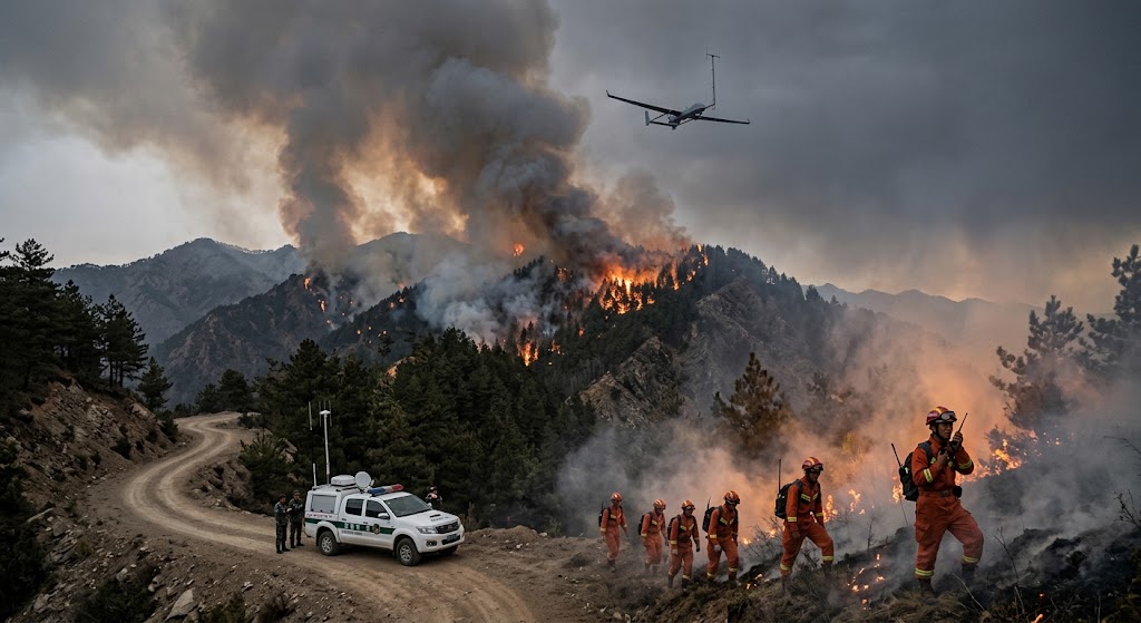
Fig. 2 | “Air-ground hybrid” networking over a plateau forest-fire ground: a drone rises as a high-ground relay while ground backpack/handheld radios relay in sliding sequence under smoke and tree-line occlusion, keeping the link following the team as the fire head moves.
AI image prompt: photorealistic scene of a forest fire on a remote high-altitude mountain range in western China, thick smoke columns rising from burning pine forest ridges, a fixed-wing drone with a relay antenna circling high above, ground firefighters in orange turnout gear spaced through smoke haze carrying backpack radios, one handheld radio operator relaying at the fire line, a command vehicle with antennas parked on a dirt access road in the foreground, overcast hazy daylight with orange fire glow, no text overlay, 8k, documentary photography style, natural backlight smoke
Citation capsule: Rescue sites commonly use three topologies: the deep linear chain (P1 placed every 500 m–2 km along the line, P5 extended at the chain head, hop count ≤3), the area mesh (several P1 units placed in a grid, P5 moving freely, the highest cellular redundancy), and the air-ground hybrid (P2 rising to fill blind spots across mountains). Uphold “save lives first, optimize later”: first open the main link between the command end (P4) and the most-forward teams (P5) to secure voice/positioning, then progressively densify placement.
— Three on-site networking topologies
How to Select a Solution and Which Products Are Recommended?
| Priority | Recommended product | Role | Why it fits |
|---|---|---|---|
| ★★★ Must-have | Backpack ad-hoc radio (P1) | Backbone-layer “mobile base station”, the core of depth-relay | MIMO 2×2, 120 Mbps @ 40 MHz, 64 nodes, IP67, 2 W, 6–12 h, SDR; raise it high and it relays — the mainstay for extending coverage with teams, fulfilling the high-ground backbone-relay role |
| ★★★ Must-have | Handheld ad-hoc terminal (P5) | Access-layer equipment worn close to the individual | Only 1.2 kg, IP66, 90 Mbps @ 20 MHz, NLOS wall penetration, 32 nodes, BD+GPS; reliable personal communications into ruins and alleys, fulfilling the access-layer portable mobile node role |
| ★★ On demand | Vehicle antenna-on-the-move MESH (P4) | Backbone-layer on-site command / forward command vehicle | 30–50 km, 90 Mbps @ 20 MHz, 2×10 W, 4G/5G public-network port, can connect an IP encryption device, BD+GPS; the hub linking front and rear and the convergence point for interoperability |
| ★ Supplemental | Drone airborne radio (P2) | Air/cross-mountain high-ground relay | Only 1.1 kg, 70 Mbps @ 20 MHz, 64 Ad hoc nodes, IP65, 2–4 W, air-ground 10 km+; fills blind spots in mountain and fire-ground occlusion scenarios |
| ★ Supplemental | Portable command/dispatch platform (P3) | Local dispatch / topology observation / priority control | 15.6-inch Win10 i7, 8G/256G, 4G/5G, IP65, GPS+BD, 14 kg, 32–64 nodes; sits at the FCP to overview the whole team without cloud-based O&M |
| ★ Specific scenario | YN300 AGV roaming relay client | Mobile roaming inside existing WiFi hot zones | Only performs seamless roaming for vehicles, AGVs and inspection robots inside existing WiFi coverage in parks/camps/venues/warehouses/fleet hot zones; not an ad-hoc backbone spanning tens of kilometers |
Citation capsule: Emergency rescue mainly recommends the “P1 backpack + P4 vehicle + P5 handheld” trio ([IEC 60529] IP67/IP66 high protection; add P2 air-ground hybrid in mountains/fire grounds and P3 dispatch at fixed FCPs), independently forming a 5–50 km private network at a “three-outage” site; P4 both serves as the on-site switching point and connects the rear via 4G/5G or satellite. Be sure to include a protocol gateway to resolve interoperability, implement compliant spectrum ([FCC 47 CFR Part 15]) and a power plan; for in-yard roaming in existing WiFi coverage, YN300 is more cost-effective.
— Summary of emergency-rescue solution selection
References
- Sichuan Provincial Emergency Management Department / Ministry of Emergency Management official website: notice on drone emergency-communications support for the Luding M6.8 earthquake.
- Ministry of Emergency Management, Guangdong Provincial Emergency Management Department, China National Defense News: coverage of the Wing Loong-2 Mesh ad-hoc base station for the Jishishan earthquake in Gansu.
- Sichuan Muli plateau “three-outage” live verification (2023-10): at an altitude of about 3,630 m, roughly 20 km apart, and under mountain occlusion, a drone carrying a Mesh ad-hoc network built an air-ground integrated emergency communications network.
- Sichuan Yajiang forest fire (2024-03): the Wing Loong-2H and Tengdun Twin Scorpion carried electro-optical/satellite/full-network-transparent air base stations cruising about 50 km² of fire ground; Sichuan county level added 279 370M ad-hoc base stations and 380 trunking base stations.
- Guangdong Provincial Emergency Management Department / Ministry of Emergency Management: support notices for the 2024 flood in Jiangwan town, Shaoguan, Guangdong and heavy rain in Huangshan, Anhui.
- Chongqing Communications Administration Bureau, Ministry of Industry and Information Technology: notice of communications support for the 2026 Pengshui mountain collapse.
- National Radio Management Regulations and emergency dedicated-band management requirements: the basis for rescue-site spectrum compliance and high-power equipment registration.
- Equipment vendor specifications (YNWMicro 1.4G MESH ad-hoc equipment and YN300 roaming relay client parameters).
- Ministry of Emergency Management official website: regulations and work updates related to emergency rescue and emergency communications support.
- Radio Administration Bureau, Ministry of Industry and Information Technology: the basis for managing emergency dedicated bands and the radio spectrum.
Notes on standard references
The meanings of the authoritative-standard codes cited inline in this article are as follows: [FCC 47 CFR Part 15] (US Code of Federal Regulations on license-exempt bands and transmit-power limits) is used for the 1.4G private band and transmit-power compliance; [IEEE 802.11s] (wireless Mesh networking protocol) is used for ad-hoc networking and multi-hop relays; [ETSI EN 300 744] (DVB-T COFDM modulation standard) is used for multipath mitigation; [IEEE 802.11n] (the 802.11n MIMO specification) is used for MIMO 2×2 spatial diversity; [ITU-R P.526] (the propagation-by-diffraction recommendation) is used for low-frequency wall penetration/diffraction capability; [IEC 60529] (classification of degrees of protection provided by enclosures) is used for the IP67/IP66/IP65 protection ratings.
FAQ
Q: If the public network is down across an earthquake zone, can an ad-hoc network form on its own?
Yes. The ad-hoc network depends on no public-network base station; devices discover each other on power-up, form the network automatically and route across multiple hops. As long as the devices are battery self-sufficient (P1 6–12 h, P5 6 h), a broadband network can be formed in real time in a “three-outage” area, then backhauled to the rear through the P4’s 4G/5G public-network port or a satellite link. The key is to control hop count to ≤3, use layered networking and give priority to the backbone.
Q: How many other devices can one device network with?
The handheld P5 supports 32 nodes, the backpack P1 and airborne P2 support 64 Ad Hoc nodes, the vehicle P4 supports ≥32 same-channel nodes, and the command platform P3 supports 32–64 nodes. Actual capacity also depends on bandwidth demand and hop count — multi-hopping shares bandwidth, and the node-count ceiling is merely the protocol capability, not “the more the better.” Only in a layered architecture, with many nodes in the backbone layer and aggregation at the access layer, can broadcast storms be avoided.
Q: How far can transmission reach under occlusion from ruins, mountain bodies and fire-ground smoke?
In the 1.4 GHz private band (1420–1520 MHz, wavelength about 21 cm), non-line-of-sight (NLOS) capability is significantly better than civilian high frequency: under occlusion from ruin walls, mountain bodies, forest and fire-ground smoke it still maintains effective communication from a few hundred meters up to a kilometer-plus; on open ground, line of sight reaches from several to tens of kilometers; air-ground (P2 aloft) reaches 10 km+, extended further with multi-hopping.
Q: Can two-way radios, ad-hoc networks and drone video transmission from different vendors be used together?
Not by default — and this is the biggest pain point in disaster response: protocol non-interoperability across vendors creates “information islands.” The solution needs a protocol gateway deployed to enable interoperability between the Mesh ad-hoc network and digital two-way radios and satellite terminals; the P4’s 4G/5G public-network port can connect an IP encryption device. Once the public network recovers, one-click docking with the dedicated command network avoids “everyone shouting on their own channel.”
Q: How long does it take to set up?
Devices complete networking automatically on power-up; the first stable link is established in about 8 seconds, and the whole network converges within tens of seconds depending on the topology size. No on-site configuration, cabling or base-station planning is required. The SDR architecture also allows remote tuning of frequency points and bandwidth from the management end, adapting to topology changes from fire drift and team movement.
Q: What are the compliance requirements for spectrum use?
Spectrum at a rescue site is extremely precious. Give priority to the dedicated band allowed by national emergency management (1.4 GHz 1420–1520 MHz — low noise floor, legally large power); high-power, long-range equipment must complete radio registration in advance; major rescue operations obey on-site radio control; and it is strictly forbidden to interfere with aviation, firefighting, meteorological and other critical radio services. This is also why 1.4G private band is recommended over civilian 2.4/5.8G.
WiFi 6 MESH Self-Organizing Network: A Complementary Architecture for Disaster Zone Communications
Key Takeaway: The 1.4G specialized-band mesh solution above is optimized for earthquake/landslide/heavy-foliage scenarios where spectrum license is available. For disaster zones requiring integration with municipal Wi-Fi clients, smartphones, and standard laptops, a complementary WiFi 6 MESH self-organizing network architecture delivers faster device onboarding without specialized client hardware. The ports are semantically peername-based, not anchored to any particular node: a responder who walks behind a collapsed structure that shadows one station re-associates with the neighbor automatically, and because no single node is the sole gateway, the command post keeps receiving that responder’s voice and video even while a mid-span unit is swapped out.
MESH vs Traditional WiFi (AP + Station) for Disaster Response
| Characteristic | Traditional WiFi (AP + Station) | MESH Self-Organizing Network |
|---|---|---|
| Setup time | 30+ minutes per AP + controller config | Power on the node — auto-joins in < 2 min |
| Handover for moving responders | Passive — waits for signal loss | Active — pre-connects based on CCQ ranking |
| Switching latency | 200–500ms (video freeze) | 20–35ms (transparent to video and voice) |
| Failure recovery | Single point of failure per AP | Auto-reroutes through neighbor nodes within seconds |
| Client compatibility | Standard Wi-Fi clients | Standard Wi-Fi clients (no specialized client radio needed) |
| Backhaul + coverage | Same radio, shared bandwidth | Tri-band: 5.8G backhaul + 2.4G/5G coverage + optional 6GHz |
Fast Roaming for Mobile Responders and Drone Surveillance
For search-and-rescue teams, drone sweeps, and ambulance handoffs between sectors, the MESH fast-roaming engine operates on five mechanisms:
- Continuous Online Scanning — idle beacon intervals used to scan candidate base stations without dropping the active link.
- CCQ-Based Ranking — Client Connection Quality composite metric weights signal strength, packet error rate, retransmission count, throughput.
- Pre-Connection — pre-auth to target station before current link degrades.
- Intelligent Data Caching — in-flight packets buffered at old station and forwarded to new station — zero loss.
- Path Learning — repeat patrol routes learn the optimal handover sequence, reducing scan time on subsequent passes.
Tri-Band Architecture for Disaster Zone RF Environment
Disaster zones create challenging RF conditions — collapsed structures, fire smoke, water spray, and temporary infrastructure. The tri-band reference design separates concerns:
- 5.8GHz (Backhaul) — directional links between MESH nodes mounted on portable masts/vehicles/drones, dedicated to inter-node traffic
- 2.4GHz (Coverage) — omnidirectional client access for handhelds, smartphones, body-cams, and medical equipment
- Optional 5GHz or 6GHz — for high-density sectors or drone video backhaul from aerial surveys
A collapsed building blocking a coverage path does not take down the backhaul. A single responder node failure does not collapse the field network — the MESH protocol reroutes through surviving links within seconds.
Field note: In a fire-ground or rescue perimeter the relevant figure is not clean roaming latency — it is how quickly a newly arrived unit can join the mesh once an incident commander sets the operating perimeter. Mobility here means a responder walking away from one node still reaches the command post through an adjacent one, and video from a hazmat or search team comes home over a path that layers in real time as units deploy. Because gear must interoperate with municipal Wi-Fi clients rather than proprietary modems, the acceptance criteria tend to be: standard WPA2/3 enterprise onboarding, sub-second mesh join for a newcomer node, and continuous forwarding while a mid-span node is swapped. Those three, more than sustained throughput numbers, decide whether the WiFi 6 MESH earns its place next to the tactical 1.4G links.
Last Reviewed: 2026-09-02
This technical guide is based on field deployment experience and reviewed by the Zukaka wireless engineering team. Specifications reference manufacturer documentation and international standards (IEC, IEEE, NFPA, ITU-T). The 1.4G specialized-band mesh and WiFi 6 MESH general-purpose solutions are complementary — deployment teams should evaluate both based on spectrum availability, regulatory environment, and client hardware compatibility.


