Forest Fire Prevention Command & Dispatch System: In High Mountains and Dense Forest, a 1.4G Mesh Weaves a “Visible Prevention-and-Control Network”
Core Overview
Who this article is for: forestry authorities, forest fire prevention headquarters, national park and reserve managers, forest fire brigades, and smart forestry system integrators — any organization that must lay a single “monitoring + command” network across high-mountain forest without public coverage.
Core problem: forest areas are largely without public networks and heavily occluded by terrain; traditional monitoring backhaul is costly to install by cable and often without coverage over the public network. In peacetime you cannot watch the fire; when a fire breaks out, it hits “triple outage,” and both the prevention and the suppression ends are missing an autonomous broadband network that can cross mountains. A qualified forest fire prevention command & dispatch system must solve both “technical prevention that sees” and “human prevention that manages” — not merely stack more cameras.
Core conclusion: this solution uses “a portable command platform (P3) as the brain + backpack-mount radios (P1) deployed along commanding heights + airborne nodes (P2) lifting off over the forest to fill coverage gaps,” forming over the 1.4 GHz private band a centrosymmetric, multi-hop, self-healing broadband ad-hoc network. Yet more than 90% of forest ignition sources are human and highly concealed; monitoring alone can never fill the “can’t-see” blind-spot of missed detection — you must use offline Mesh trunking intercom + smart patrol terminals to back up “human-prevention communications,” and then use the platform to link “monitoring alarms ↔ manual verification” into a closed loop before the network can truly hold year-round. Tunnel conclusion: front-end backhaul over long distance, occlusion, and no infrastructure within the forest uses 1.4G Mesh; cross-campus watchtowers, ranger-station interiors, and mobile inspections that already have WiFi use a lightweight AGV roaming relay client.
Why Is a Forest Environment “Hard to Manage” by Nature?
Before choosing equipment or settling on a solution, the forest “battleground” itself must be understood. Every environmental trait directly dictates how communications, power and detection should be designed. Here are six realities that can never be avoided.
- Complex terrain, heavy occlusion: forest mountains, hills and ravines are dense, with large elevation differences; trees and bamboo blocks wireless line of sight and RF links, and ridgelines readily create signal blind zones. This interferes both with fixed-monitoring wireless transmission and with patrol personnel mobile communications — valleys, leeward slopes and dense forest are extremely prone to communication loss.
- Harsh, changeable weather: large day-night temperature swings, frequent heavy fog, rain/snow, lightning and gusty wind; hot and humid in summer, icing and frost in winter. Severe weather not only causes equipment faults, link fluctuation and declining solar output, it also worsens public-network attenuation, so on-site reporting of fires and hazards by patrols is easily blocked.
- Scant infrastructure, fragmented public coverage: the vast majority of sites have no mains power, so monitoring relies on solar energy storage; forest lacks communications infrastructure, and 4G/5G covers only edge areas. Patrol personnel have no fixed supply, terminals run on their own batteries, and offline-ops communications assurance is extremely difficult.
- Poor access and maintenance conditions: monitoring sites are scattered, deep-mountain vehicles cannot reach many, and repair cycles are long; patrol routes are scattered and wide, dense-forest blind areas are hard to hike, traditional manual checks easily miss routes, and work traces are hard to supervise.
- Human-dominated, highly concealed ignition sources: more than 90% of forest fires are human-caused — ritual burning, slash-and-burn, open-air cooking, leftover cigarette ends. Early-stage fires are mostly understory smoldering or surface embers with no smoke and no flame, which cameras and thermal imaging cannot identify; only close-range manual inspection can. This is precisely why “human prevention” is always the last line of defense in a fire-prevention system.
- Clean electromagnetic environment with random mobile interference: standing interference in forest is low; nearby villages, base stations and mine areas produce 4G/5G, WiFi and intercom clutter. Patrol personnel keep moving and terrain constantly changes, so signal fluctuates markedly and fixed communications parameters cannot fit the mobile single-soldier scenario.
Citation capsule: forest-area fire prevention is hard because of six realities: terrain occlusion, harsh weather, fragmented public coverage, poor access and maintenance, ignition sources more than 90% human and highly concealed, and a random electromagnetic environment. The first four dictate how fixed monitoring is done, the last two how human-prevention communications are done — and concealed human ignition sources are precisely the variable that hardware-minded thinking most easily ignores yet that most decides success, which is why “human-prevention communications backup” must be part of the solution.
— Forest Fire Prevention Command & Dispatch System
Why Do Both Prevention and Suppression Stall on “No Network”?
Forest fire prevention’s demand on communications is by no means “just having a signal” — it is pinned by three hard constraints.
Pain point 1: vast terrain, spare population, public coverage cannot reach deep mountains
A county-level forest often spans dozens to hundreds of kilometers, with watchtowers, ranger points and entrance checkpoints scattered across ridgelines and hollows. Carriers build base stations by ROI and will not blanket an unpopulated forest. The result: ranger points are “manned posts with no network” year-round, fire reports rely on manual phone calls or cannot be raised at all, and video surveillance is useless because there is no backhaul channel.
Pain point 2: rolling terrain, line-of-sight communications cannot cross that ridge
Even with wireless equipment, most civilian point-to-point bridges are line-of-sight (LOS); a single ridgeline or slice of dense forest breaks the link. Between points at a mountain forest farm there is, precisely, one ridge after another. This is not a power problem; it is “cannot cross” caused by choosing the wrong frequency band. Later we explain specifically why 1.4 GHz can cross.
Pain point 3: once a fire starts it hits “triple outage,” and on-site command is completely out of touch
The most lethal part of an incident is “broken road, broken network, cut power.” Fiber burns, base stations lose power, roads close, and the frontal suppression force loses contact with the headquarters. With thick smoke, flying embers and changing wind direction in the fireground, without real-time location and backhaul the commander can only “guess by experience,” and crew safety cannot be confirmed in real time. That “wartime link break” is precisely what the peacetime-deployed network can rescue.
Stringing the three pain points together, the conclusion is clear: the forest needs an autonomous network that “does not depend on the public network, crosses mountains and obstacles, supervises monitoring in peacetime, and guarantees command in wartime” — this is exactly the value starting point of ad-hoc networking, but it is also scenario-dependent and cannot blindly pile 1.4G Mesh across the board.
Citation capsule: forest fire prevention communications are pinned by three hard constraints: vast sparely-populated terrain keeps public coverage from reaching deep mountains, rolling terrain keeps line-of-sight bridges from crossing ridgelines, and once a fire starts it hits “broken road, broken network, cut power.” Stacked together, the conclusion is to bound the boundary first rather than blindly pile 1.4G Mesh: deep-mountain valley roads and the fireground no-network zone belong to the ad-hoc network, while watchtower/ranger-station interiors that already have WiFi coverage use a roaming relay client only.
— Forest Fire Prevention Command & Dispatch System
From “Seeing” to “Managing,” What Is So Hard?
The environment determines that it is hard to do; the difficulty then spans six major blocks. The environment traits above explain “why it is hard”; here we break down “where the difficulty and the blocker lie.” Many projects do not fail for lack of equipment but because these short boards stack on top of one another.
1) Difficulty of fixed-monitoring wireless transmission
- Fiber construction is costly and forest coordination is difficult, unfit for wide-area deployment;
- Public coverage is insufficient, and data traffic fees accrue continuously over the long term;
- Ordinary wireless bridges rely on line of sight, and trees grow taller year after year to occlude the link, causing frequent monitoring disconnects.
2) Difficulty of off-grid power supply
- Solar generation is affected by sunlight, canopy occlusion and season, with blackout risk during consecutive overcast/rainy days;
- Storage batteries lose capacity in low temperatures; lacking remote monitoring, aging faults cannot be pre-warned;
- Patrol single-soldier terminals have no external replenishment, and long-duration field operations put heavy pressure on endurance.
3) Difficulty of video perception and detection
- Visible-light cameras fail at night; thermal imaging is limited by rain/fog and vegetation occlusion, and long-distance detection is restricted;
- Leaf motion, glints and flying birds cause massive false alarms;
- Shallow understory smoldering fire is concealed by the canopy, so equipment has an inherent missed-detection blind zone.
4) Dedicated difficulty of manual-patrol communications
- Heavy dependence on the public network: deep mountains have no mobile signal, so hazards and fires cannot be reported in real time;
- Short intercom range: weak mountain penetration prevents cross-valley coordination;
- Lack of offline communications: personnel entering a no-signal area go out of touch, a safety risk;
- Lack of digital supervision: traces and hazard records cannot be retained, and missed patrols or unreported items are hard to manage.
5) Difficulty of human-machine coordination and linkage
- Technical-prevention monitoring and manual patrol are independent; when monitoring raises a suspected alarm, the nearest ranger cannot be dispatched on site to verify;
- When a patrolman finds a concealed ignition source, the PTZ camera cannot be quickly moved in to collect evidence;
- Alarm information and patrol ledgers belong to two separate systems, and emergency dispatch efficiency is low.
6) Difficulty of construction and maintenance
- Mountain pole installations demand high standards of wind-resistance, lightning protection and waterproofing; scattered sites and late fault discovery;
- Patrols lack a standardized communications work flow, and hazard reporting and fire handling lack a regulated mechanism.
Citation capsule: six short boards of a forest fire prevention system: fixed-monitoring wireless transmission, off-grid power supply, video perception and detection, manual-patrol communications, human-machine linkage, and construction/maintenance. The first three are old hard problems of traditional monitoring; the last three are short boards of the human-prevention system long neglected — and manual-patrol communications is the most lethal of them: ignition sources are 90% human, yet patrols are exactly the segment with the least communications support, directly deciding prevention success.
— Forest Fire Prevention Command & Dispatch System
Which Section of the Forest Uses 1.4G Mesh, and Which Uses the Roaming Client?
Many integrators want “Mesh across the whole forest” right away, which is not economical. The sound approach is to cut the forest into two classes by “distance + whether basic network exists.”
| Judgment dimension | Use 1.4G Mesh ad-hoc network (P1/P2/P3) | Use AGV roaming relay client (YN300) |
|---|---|---|
| Backhaul distance | Several km to 50 km, cross-mountain/cross-region multi-hop | Within a single coverage domain, hundreds of meters to 1-2 km |
| Line-of-sight occlusion | Non-line-of-sight: ridgelines, dense forest, heavy smoke | Gently rolling campus, weak occlusion |
| Infrastructure | Completely no public network, no WiFi | Watchtower/ranger station/camp already has APs or an upper network |
| Mobile access | Squads/vehicles maneuver in a no-network area, need multi-hop | Inspection/ranger vehicles roam seamlessly within coverage hot zones |
| Band / power | 1.4 GHz private band, legally high power | 2.4G/5.8G civilian WiFi, low power |
| Form factor | Outdoor IP66/67, rain and dust protected | Small board/CPE, mounts to vehicles/robots, needs enclosure for open air |
| Typical configuration | P1 backpack + P3 platform + P2 airborne | YN300 client/relay + existing AP |
In summary: the forest’s “wilderness segment” and “fireground no-network segment” belong to 1.4G Mesh; any “campus segment / near-adjacent segment” where WiFi coverage exists and mobile equipment only needs to roam between hot zones belongs to the YN300 roaming relay client. Walking on both legs with the right tool for each segment gives the best cost and effect.
Citation capsule: the forest network boundary is cut into two classes by “distance + whether basic network exists”: tens-of-kilometers deep-mountain backhaul and the fireground no-network zone must use 1.4G Mesh ad-hoc networking (P1/P2/P3, cross-mountain multi-hop, non-line-of-sight); watchtower/ranger-station interiors, camps, and mobile inspections that already have WiFi can use the YN300 roaming relay client (cheaper, more power-efficient). The test is one sentence: wilderness with no network belongs to the ad-hoc network; campus and near-adjacent segments belong to the roaming client.
— Forest Fire Prevention Command & Dispatch System
Real Events: the Muli “Triple Outage” and the Yajiang Fire
The 2023 Muli Plateau “Triple Outage” Verification, Sichuan
In October 2023, a combat verification was run on the Muli Plateau, Sichuan: the site was at an altitude of about 3,630 m, and the incident site was about 20 km from the command center with mountain occlusion in between. The solution used a UAV carrying Mesh ad-hoc networking to build an air-ground integrated emergency communications network, backhauling on-scene audio/video and location data in high definition, completing beyond-line-of-sight UAV emergency communications assurance. The organizers were the Department of Science, Technology and Informatization of the Ministry of Emergency Management and the China Fire and Rescue Institute. Note the difficulty: 20 km is not visible in a straight line — a mountain lies in between, and an ordinary line-of-sight bridge cannot break through at all; only a combination of low-frequency diffraction plus an aerial relay works.
The 2024 Yajiang Forest Fire, Sichuan
In March 2024, in the Yajiang forest fire in Sichuan, the Wing Loong-2H and the Tengdun Double-Scorpion carried electro-optical reconnaissance pods, satellite communications, and all-network aerial base stations, continuously cruising and relaying above the fireground to hold stable coverage of about 50 km² over a long period. Sichuan added 279 county-level 370M ad-hoc base stations and 380 trunking base stations, forming a hybrid architecture of “aerial base station + ground ad-hoc network.” The division of labor behind this is exactly what we described earlier: the aerial base station handles large-area last-resort coverage, while the ground ad-hoc network goes into mountains and forest to extend command to the very front of the fire line.
Citation capsule: the Muli Plateau 3,630 m “triple outage” verification and the Yajiang fire verified the same playbook: UAV-carried Mesh + ground ad-hoc network + aerial base station build air-ground integrated emergency communications. At Muli, the site and command center were about 20 km apart with mountain occlusion, and an ordinary line-of-sight bridge cannot break through, so low-frequency diffraction plus an aerial relay is required; at Yajiang, multi-aircraft platforms such as the Wing Loong carried aerial base stations for areal last-resort coverage while the ground ad-hoc network penetrated mountain valleys and forest to extend command.
— Forest Fire Prevention Command & Dispatch System
Why Do Civilian High Frequencies Fail in the Forest?
To understand why the forest must use low frequency, look at what actually happens when an electromagnetic wave passes through vegetation.
The relationship between attenuation and frequency
Vegetation leaves and branches are rich in water, and water molecules strongly absorb microwaves. The higher the frequency, the shorter the wavelength, and the worse the scattering and absorption on encountering leaves. The vegetation attenuation model in [ITU-R P.833] shows that at 2.4 GHz and 5.8 GHz, the equivalent attenuation of a single-story deciduous stand is far greater than at 1.4 GHz. That is the physical cause of “no signal once in the woods” — not bad equipment, but the wrong band.
- Diffraction: the diffraction-propagation model of [ITU-R P.526] shows low frequency bends around edge obstacles more easily; the 1.4 GHz wavelength is far longer than 5.8 GHz (about 21 cm vs about 5.2 cm), so it more easily bends around ridgelines and trunk undulations to sustain the link.
- Penetration: low frequency attenuates less through vegetation and terrain undulation, has stronger non-line-of-sight capability, and holds more steadily through dense forest and over the canopy.
- Coverage: at the same transmission power, the 1.4 GHz effective coverage distance in forest far exceeds 5.8 GHz, meaning fewer relay points and less investment.
- Legally high power: as a 1.4G private band, it may legally use higher transmission power to make up long-distance attenuation — something the civilian ISM band cannot do. [FCC 47 CFR Part 15] sets power and duty-cycle limits on license-exempt high-band devices, further capping the usable link budget of civilian high frequency in long-distance forest backhaul.
The civilian WiFi band was designed for indoor local-area use — forest is its “forbidden zone”; the 1.4G private band turns “crossing the woods and riding over ridgelines” from impossible into an engineering routine.
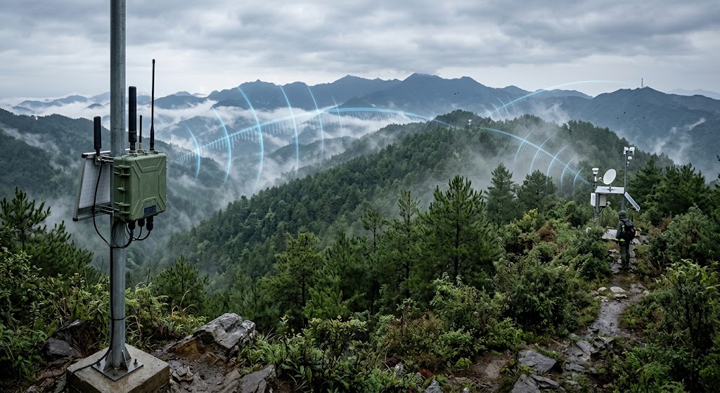
Fig. 1 | A relay-link illustration of the forest-area 1.4G Mesh radio wave passing through the canopy and bending around a ridgeline (actual deployment scenario).
Citation capsule: the physical root cause of civilian high-frequency failure in the forest is vegetation absorbing water: the [ITU-R P.833] vegetation attenuation model shows equivalent attenuation rises markedly as frequency increases, so 2.4G/5.8G single-story deciduous stands attenuate far more than 1.4 GHz; add “one low, one high” — the 1.4 GHz wavelength of about 21 cm diffracts and penetrates more easily, [ITU-R P.526] supports it bending around ridgelines, and the 1.4G private band can legally use high power. That is why 1.4G Mesh is the natural forest choice.
— Forest Fire Prevention Command & Dispatch System
How Is the Forest-Area Network Built?
Architecturally, we split the forest network into three layers: dispatch, backbone, and access. With the responsibility of each layer clear, product selection has a basis.
| Layer | Role | Recommended equipment | Key capability |
|---|---|---|---|
| Dispatch | On-site command post / monitoring center | Portable command platform P3 | Big screen monitoring, audio/video dispatch, 4G/5G backhaul, GPS+BD, 32–64 nodes |
| Backbone | Distributed along ridgelines/watchtowers/checkpoints for long-term backhaul | Backpack-mount radio P1 | 120 Mbps, 64 nodes, IP67, 6–12 h / mains power, can act as temporary relay |
| Access | Lift off over forest to fill gaps, cross-mountain relay | UAV-carried node P2 | Air-ground 10 km+, 70 Mbps, lightweight 1.1 kg, 4–2 W |
| Access | Mobile inspection roaming around campus/camp | YN300 roaming relay client | 2.4G/5.8G dual band, client+relay dual mode, seamless roaming, low power |
The P3 platform is sited at a county/city-level/front-line command post; monitoring watchtowers and patrol points use P1 to carry front-end video and sensor data back over multiple hops. When a fire breaks out, the same set of nodes is adjusted in place: P1 is redeployed to commanding heights upwind of the fire, P2 lifts off to fill coverage gaps, and P3 converts in place into a fireground command platform, smoothly switching a “prevention network” into a “suppression command network.” For points near camps and watchtower buildings that have power and network, use YN300 to bring station interiors, duty rooms and parked patrol vehicles into one unified network without occupying a 1.4 GHz channel.
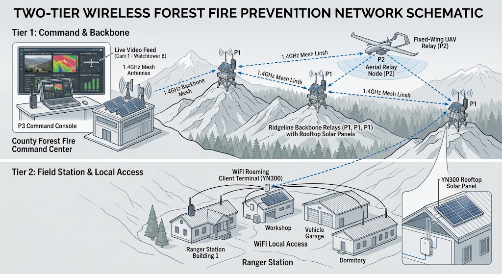
Fig. 2 | Two-tier networking: 1.4G Mesh covers the forest wilderness segment, and the camp/watchtower near-adjacent segment joins via a YN300 roaming client.
Citation capsule: the forest network has three layers: the dispatch layer uses the P3 portable command platform as the on-site command post and monitoring center, doubling as 4G/5G backhaul; the backbone layer uses the P1 backpack radio deployed along ridgeline watchtowers for long-term backhaul of monitoring and patrol data; the access layer uses the P2 airborne node to lift off and fill gaps, and the YN300 roaming client to take the camp/watchtower near-adjacent segment. When a fire occurs, the same set of nodes converts in place into a suppression command network — P3 becomes the forward command post, P1 is redeployed to fireground commanding heights, and P2 lifts off for cross-mountain relay.
— Forest Fire Prevention Command & Dispatch System
How Do the Prevention ↔ Suppression Two Networks Switch Over?
The key is “switch,” not “rebuild”: the long-online batch of nodes in the prevention network need not be dismantled during a fire — redefine routing priority and bandwidth allocation, push command traffic to the very front, and the fire-line crews’ handheld terminals simply join the network. [IEEE 802.11s] defines the self-organizing and multi-hop routing protocol of wireless mesh networks; the same nodes reuse the same network to add or remove service flows — that is the value of the same protocol, same band, and free mixed grouping.
Citation capsule: the same set of 1.4G nodes can become two networks: in peacetime the prevention network is permanently installed along watchtower/checkpoint/ridgeline positions, mostly chain + mesh, backhauling monitoring, thermal imaging and fire alarms; during a fire the suppression network has P3 set up a forward command post, P1 redeployed to commanding heights upwind of the fire, and P2 lifting off for cross-mountain relay, with multi-hop command audio/video reaching the fire line directly. The switch relies on [IEEE 802.11s] ad-hoc routing redefinition rather than rebuilding, so the nodes deployed in peacetime are not dismantled during a fire.
— Forest Fire Prevention Command & Dispatch System
How Is Power Supply Reliability Assured for Long-Cycle Deployment?
The prevention network is “unattended, on line year-round,” which determines that it follows a different logic from temporary network rigging. The reliability design revolves around three things:
- Long-term power supply: fixed nodes carry solar panels + storage batteries; battery sizing and installation details are covered in deployment step 3, “Power system configuration optimization,” sized for a “3–7 consecutive overcast/rainy days without dropping” margin to keep unattended sites on line year-round; watchtowers with mains power directly use external power.
- Redundant links: key monitoring points are equipped with standby relays; a single-point power outage or cable break routes around automatically, so one node fault does not take down the whole string.
- Scheduled inspection: periodically use a drone or manual checks to verify link quality and bandwidth and assess whether points need to be added or the topology adjusted, preventing silent degradation.
- All-in-one backhaul: the front end integrates thermal fire detection, and anomalies alarm to the platform automatically, upgrading “watching monitoring” into “automatic discovery” and reducing manning effort.
For points near camps that have mains power and network, use the YN300 roaming relay for station/duty-room/patrol-vehicle access — low power and flexible, able to hold year-round on-line operation without occupying a 1.4G backbone channel.
Citation capsule: long-term forest deployment fears most “the power goes out and no one manages it”; reliability revolves around three things: long-term power supply — fixed nodes carry solar + storage batteries, sized for 3–7 consecutive overcast days without dropping, and watchtowers with mains power use external power directly; redundant links — key monitoring points carry standby relays with automatic reroute on a single-point fault; scheduled inspection — periodic drone or manual verification of link bandwidth. Storage uses low-temperature-type batteries with remote monitoring to prevent silent degradation.
— Forest Fire Prevention Command & Dispatch System
Core Problem: Four Hurdles, “Why It Can’t Be Prevented”
Pulling the environmental traits and the six major difficulties together, forest fire prevention is intrinsically stuck on four hurdles. The first three are the ceiling of the technical-prevention system; the last is the life-and-death point that truly decides success or failure yet is most often ignored.
1) Technical prevention has inherent coverage short boards
Wireless monitoring always faces four contradictions — link stability, power continuity, detection accuracy, and full-area coverage: fiber is costly, wireless bridges are constrained by vegetation, solar power is limited by climate, AI algorithms have false positives/negatives, and the concealed human ignition source under the forest canopy cannot be detected at all. Relying on monitoring alone can never achieve full-area fire prevention.
2) Human prevention lacks reliable communications backup (the critical pain point)
Human ignition sources are the leading cause of fires, and concealed smoldering fires can only be found by manual inspection. But existing patrols depend on public networks and legacy intercoms: communications break in no-network areas, multiple squads cannot coordinate, work processes cannot be supervised, and hazard reporting lacks a stable channel. The lack of communications support for human-prevention forces is the single greatest vulnerability of the forest fire prevention system.
3) The system is disjointed between machine and human, unable to close the loop in handling
Monitoring only generates alarms, and patrols only do on-foot inspection; the two lack a two-way linkage mechanism. It cannot achieve “equipment alarms send people to verify; personnel-find hazards get re-checked by video.” The strengths of technical and human prevention cannot complement each other, and the handling chain breaks.
4) Heavier on hardware construction, lighter on long-term operations assurance
Many projects only complete the installation of monitoring equipment, without optimizing communications and power solutions for forest terrain, lack human-prevention communications support, and have an incomplete maintenance mechanism. The system is usable short-term but its fault rate keeps rising mid/long term, making it unable to support routine fire prevention work.
Citation capsule: forest fire prevention is stuck on four hurdles: technical prevention has inherent coverage short boards (fiber is costly, wireless is blocked by vegetation, solar is limited by climate, understory smoldering cannot be detected); human prevention lacks reliable communications backup — human ignition sources are the leading cause and concealed smoldering fires can only be found manually, yet patrols are the segment with the least communications; the system is disjointed between machine and human and cannot close the handling loop; and hardware construction is emphasized over long-term operations. The first two are solved by network selection, the third by platform linkage, and the fourth by an operable, replicable project.
— Forest Fire Prevention Command & Dispatch System
From Survey to Human-Machine Linkage, How Are the Eight Procedures Done?
1. Early survey and overall point-site planning
- Fixed monitoring should prioritise mountain tops and lookout-tower commanding heights, reserving room for tree growth; use terrain-simulation tools to verify the Fresnel zone of wireless links and avoid occlusion.
- In parallel, plan Mesh communications gap-filling nodes to cover valleys, dense forest, main patrol arterials and monitoring blind zones, balancing video backhaul and patrol single-soldier communications needs.
- Plan nodes in layers: backbone nodes (long-distance backhaul along ridgeline watchtowers), collection nodes (front-end monitoring/sensors), and mobile gap-filling nodes (vehicle/airborne/single-soldier).
2. Wireless communications networking deployment (fixed equipment + mobile single-soldier integrated)
- Adopt a hybrid architecture of “commanding-height directional bridges + in-forest Mesh ad-hoc network + single-soldier mobile communications”: 5.8G directional bridges build backbone high-speed links carrying video; 2.4G Mesh nodes are used to fill dense-forest gaps and improve diffraction performance.
- Equip patrol personnel with Mesh single-soldier terminals that support trunking intercom, location, and image/text/video reporting even without the public network.
- Plan channels uniformly to avoid co-channel interference; deploy 4G/5G links at important lookout points as communications backup.
- Strictly comply with radio-management regulations; high-power point-to-point equipment must be registered with the local radio authority as required.
3. Power-system configuration optimization
- Tilt and raise the solar modules to face south, avoiding canopy occlusion; size storage for 3–7 consecutive sunless days and use low-temperature-type batteries.
- Insulate and dehumidify the battery compartment, remotely monitor voltage/current, and pre-warn on low voltage.
- Equip portable charging gear for single soldiers to secure patrol terminal endurance, building a dual power-assurance scheme of “fixed points + mobile terminals.”
4. Equipment selection and full-area lightning protection
- Use dual-spectrum, wide-temperature PTZ cameras for monitoring, with lens heating and defogging.
- Implement three-level lightning protection across the system: pole lightning rods, surge protectors at both ends of network/power/RF cables, and grounding resistance ≤ 4 Ω.
- Use industrial waterproof, drop-resistant single-soldier terminals; enclosures use rust-proof aluminum alloy with dehumidification/temperature-control modules to prevent internal condensation from corroding PCBs.
5. Civil construction standards
- Design pole foundations for mountainous gust wind loading to ensure wind resistance; use waterproof connectors on cables and reserve thermal-expansion/contraction slack.
- Raise enclosures above the ground to avoid water and snow accumulation, and add anti-theft devices.
- Design small Mesh gap-filling nodes lightweight, fit for rapid installation in roadless areas.
6. Dedicated deployment of manual patrol “fire-and-electrical inspection” communications
- Build an offline trunking intercom dispatch system on the forest Mesh backbone to enable communications for patrol squads across valleys and zones.
- Equip offline smart patrol terminals that can cache hazard images/text/video in no-signal areas and automatically sync once communications recover; establish standardized reporting flows for outdoor-fire use, ritual hazards and understory smoldering fire.
- Enable a personnel-location system with real-time position viewing, track playback and check-in patrols to eliminate skipped and missed patrols.
7. Build a closed-loop human-machine linkage mechanism
- When monitoring raises a suspected-fire alarm, the platform automatically pushes it to the nearest patrolperson for on-site verification and feeds back the result.
- When a ranger reports an ignition hazard, the platform moves the nearest PTZ camera to zoom in and collect evidence.
- Manage alarms in grades — general hazard, suspected fire, confirmed fire — linked with emergency broadcast and message push, forming the complete “monitor — report — verify — handle” closed loop.
8. Platform integration and maintenance assurance
- Reserve platform interfaces to support integration with forestry and emergency higher-level command platforms, aggregating video, fire alarms and patrol-ledger data.
- Adopt a “remote monitoring + periodic on-site inspection” model: remotely view equipment power, signal and personnel patrol status; run site-wide inspection before the critical fire-prevention season.
- Stock spare parts such as bridges, surge protectors and single-soldier terminals at management stations to shorten repair time.
Citation capsule: forest fire prevention deployment follows eight procedures: survey and point-siting, wireless networking, power optimization, lightning protection, civil construction, patrol communications, human-machine linkage, and platform maintenance. The last three are most likely to be cut — human-prevention communications, human-machine linkage and maintenance assurance — yet exactly these decide whether the system can hold long-term. In practice, prioritise placing nodes at human-accessible commanding heights and pulling mains/solar power, which is more efficient and reliable than “hand-carrying everything / swapping batteries.”
— Forest Fire Prevention Command & Dispatch System
Solution Product Recommendations: What Configures Best with This Package
Here are the product recommendations that best fit the current solution, in order of priority.
| Priority | Recommended product | Role in this solution | Why it fits |
|---|---|---|---|
| ★★★ Must-have | Portable command platform P3 | On-site command post / dispatch brain | Monitor on-screen, one-key dispatch, multi-network backhaul; the hub of integrated prevention and suppression |
| ★★★ Must-have | Backpack-mount MESH radio P1 | Forest backbone relay / long-range backhaul | 120 Mbps, 64 nodes, IP67, solar powered; the main force crossing mountains and obstacles |
| ★★ On-demand | UAV-carried node P2 | Fireground lift-off gap-filling / rapid emergency build | Lifts off within minutes during a fire, cross-mountain gap-filling, 1.1 kg lightweight, mountable to multiple aircraft |
| ★★ On-demand | Vehicle antenna-on-the-move MESH P4 | Antenna-on-the-move for forest vehicles/command vehicles | Keeps the backbone while the convoy moves, fit for the forward-post vehicle following suppression |
| ★ Supplementary | YN300 roaming relay client | Camp/watchtower near-adjacent WiFi roaming access | Mobile roaming among station buildings, duty rooms and parked patrol vehicles; low-cost finish |
Citation capsule: the most balanced forest fire prevention product combination is “P3 portable command platform + P1 backpack radio + P2 UAV-carried node” — the brain, backbone and gap-filling trio covers the greatest demand of the forest no-network segment; when the budget is tight, secure the P1 backbone and P3 first and make coverage solid. When the camp/watchtower near-adjacent has WiFi roaming needs, add YN300 as a low-power finish, but never as a cross-mountain backbone.
— Forest Fire Prevention Command & Dispatch System
FAQ
Q: With no public network in the deep mountains and dense forest, how far can Mesh cover?
The 1.4 GHz private band penetrates and diffracts through vegetation and terrain undulation far better than 2.4G/5.8G; typical forest point-to-point coverage can reach several to tens of kilometers, and with multi-hop relays along ridgelines plus airborne lift-off, it can cover monitoring and suppression areas of tens of kilometers.
Q: Can peacetime monitoring and fireground command use the same equipment?
Yes. The same set of 1.4G ad-hoc nodes is permanently installed along checkpoints and watchtowers in peacetime for monitoring and patrol backhaul; when a fire occurs, the command platform is moved up front, nodes are redeployed to fireground commanding heights, and it switches smoothly into a fireground command network — the two uses share and reuse one network.
Q: What if the forest fixed nodes have no power?
Fixed nodes can be fitted with solar panels + storage batteries for long-term supply and unattended operation; the backpack-mount unit carries 6–12 hours of battery and, in temporary scenes such as a fireground, can run independently or off external power. The equipment protection ratings are IP67/IP66 (the enclosure-protection code defined in [IEC 60529]), fit for the rain- and sand-exposed forest environment.
Q: Why does civilian WiFi lose its signal as soon as you enter the woods?
Leaves and trunks are high in water content and strongly absorb high-frequency electromagnetic waves. The [ITU-R P.833] vegetation attenuation model shows equivalent attenuation rises markedly as frequency increases; 2.4G/5.8G are high-frequency with short wavelengths and attenuate sharply in vegetation; the 1.4 GHz wavelength is several times longer, attenuates less, and diffracts more easily, so it performs far better in forest than civilian high frequency.
Q: Which scenarios don’t actually need 1.4G Mesh, and a roaming client is enough?
When equipment only needs to roam between hot zones that already have WiFi coverage — campuses, watchtower buildings, camps and patrol vehicles — the YN300 roaming relay client is cheaper and simpler; only cross-mountain, long-distance, no-public-network, multi-hop front-end backhaul and fireground no-network command require 1.4G Mesh.
Q: How do forest fire prevention and wartime suppression share one network?
In peacetime the P3 platform aggregates video from all monitoring points for fire detection and patrol dispatch; in wartime the platform converts in place into the forward command post, with multi-hop audio/video and location reaching command directly. Through the same protocol and nodes, an integrated autonomous broadband network serves both prevention and suppression.
Q: How do rangers communicate and report fires when they enter deep mountains with no mobile signal?
Give patrol personnel offline Mesh single-soldier terminals that support trunking intercom, location and image/text/video reporting even without the public network; in a no-signal area, hazard data can be cached locally and auto-synced once back in a covered area. Add the offline smart patrol terminal’s personnel location and track playback to eliminate skipped and missed patrols. This is the core instrument of “human-prevention communications backup.”
Q: When monitoring alarms, how do we get the nearest ranger to verify?
Through the “human-machine linkage closed loop”: when monitoring raises a suspected fire, the platform pushes it automatically to the nearest patrolperson by location for on-site verification and result feedback; when a ranger reports an ignition hazard, the platform moves the nearby PTZ camera to zoom in and collect evidence. Alarms are graded by “general hazard / suspected fire / confirmed fire,” linked with emergency broadcast and message push, forming a complete handling chain.
Q: Forest monitoring runs on solar, so what about blackouts during consecutive overcast/rainy days?
Tilt and raise the solar modules toward the south to avoid canopy occlusion; size storage for 3–7 consecutive sunless days and use low-temperature-type batteries; insulate and dehumidify the battery compartment and remotely monitor voltage/current for low-voltage pre-warning. Patrol terminals are additionally equipped with portable charging gear, building a dual power-assurance scheme of “fixed points + mobile terminals.”
References
- Department of Science, Technology and Informatization of the Ministry of Emergency Management & the China Fire and Rescue Institute: brief report of the “triple outage” combat verification on the Muli Plateau, Sichuan.
- Sichuan Provincial Department of Emergency Management: aerial base station and ad-hoc base station data for the Yajiang forest fire.
- Beifeng Communications / Xinuaomaitian, et al.: black, Hebei, Sichuan and Yunnan provincial-level forest fire prevention Mesh deployment solutions.
- YNWMicro P1 backpack-mount / P3 portable command platform / YN300 roaming relay client product datasheets.
- Official website of the Ministry of Emergency Management: regulations and work updates on forest-grassland fire prevention/extinguishment and emergency communications assurance.
- China.gov.cn – Radio Administration Regulations: regulations basis and departmental rules for forest radio-communications frequency compliance.
Standard reference note: in this article [ITU-R P.833] denotes the ITU Radiocommunication Sector recommendation on vegetation-attenuation propagation; [ITU-R P.526] denotes the recommendation on diffraction propagation; [IEEE 802.11s] denotes the wireless-mesh (Mesh) self-organizing and multi-hop routing standard; [FCC 47 CFR Part 15] denotes US federal regulations on the power and duty cycle of license-exempt radio devices; [IEC 60529] denotes the international enclosure-degree-of-protection (IP code) standard. These standards are used only to state technical basis and terminology sources; equipment parameters and engineering judgments in this article follow the YNWMicro public datasheets and related public cases.
— Forest Fire Prevention Command & Dispatch System
WiFi 6 MESH Self-Organizing Network: A Complementary Architecture for Wildfire Surveillance
Key Takeaway: The 1.4G specialized-band mesh solution above is engineered for forest canopy penetration, salt-spray resistance, and long-distance mountainous surveillance. For patrol vehicles, drone sweeps, and integration with municipal WiFi clients at ranger stations, a complementary WiFi 6 MESH self-organizing network architecture delivers higher throughput and easier client onboarding. Routing is distributed rather than anchored to one station: when a watchtower’s node drops off, its camera feeds and any ranger clients re-enter through the two nearest neighbors, so a surveillance link is never hostage to that single tower’s uplink.
MESH vs Traditional WiFi (AP + Station) for Forest Environments
| Characteristic | Traditional WiFi (AP + Station) | MESH Self-Organizing Network |
|---|---|---|
| Handover for patrol vehicles | Passive — waits for signal loss | Active — pre-connects based on CCQ ranking |
| Switching latency | 200–500ms (video freeze) | 20–35ms (transparent to video and voice) |
| Failure recovery | Single point of failure per AP | Auto-reroutes through neighbor nodes within seconds |
| Backhaul + coverage | Same radio, shared bandwidth | Tri-band: 5.8G backhaul + 2.4G/5G coverage + optional 6GHz |
| Network expansion (peak fire season) | Requires controller reconfiguration | Add temporary node, power on — auto-joins |
Fast Roaming for Patrol Vehicles and Drone Surveys
For ranger patrol vehicles, aerial drone fire-perimeter surveys, and rapid-response crews, the MESH fast-roaming engine operates on five mechanisms:
- Continuous Online Scanning — idle beacon intervals used to scan candidate base stations without dropping the active link.
- CCQ-Based Ranking — Client Connection Quality composite metric weights signal strength, packet error rate, retransmission count, throughput.
- Pre-Connection — pre-auth to target station before current link degrades.
- Intelligent Data Caching — in-flight packets buffered at old station and forwarded to new station — zero loss.
- Path Learning — repeat patrol routes learn the optimal handover sequence, reducing scan time on subsequent passes.
Tri-Band Architecture for Forest RF Environment
Forest RF environment is challenging — dense canopy, mountain shadowing, and water-vapor attenuation. The tri-band reference design separates concerns:
- 5.8GHz (Backhaul) — directional links between watchtower MESH nodes, dedicated to inter-node traffic
- 2.4GHz (Coverage) — omnidirectional client access for ranger handhelds, body-cams, and ground sensors
- Optional 5GHz or 6GHz — for high-density zones or drone video backhaul from aerial fire-perimeter surveys
A mountain ridge blocking a coverage path does not take down the backhaul. A single watchtower node failure does not collapse the surveillance network — the MESH protocol reroutes through surviving links within seconds.
Design note: In a forest-surveillance context the MESH layer should be judged on two behaviors that the 1.4G backbone does not optimize for: carrying bursty HD video from a mobile drone toward a watchtower, and giving ranger-station Wi-Fi clients a standards-compliant path to the same aggregation point. Neither is a roaming-throughput problem — both are bottleneck problems at the last hop. Budget the number of drones actively streaming at once against the backhaul capacity of their nearest node, and confirm the node that receives the drone stream can also backhaul it in the same band, otherwise the limiting link will be inside the tower, not the path between towers.
Last Reviewed: 2026-09-02
This technical guide is based on field deployment experience and reviewed by the Zukaka wireless engineering team. Specifications reference manufacturer documentation and international standards (IEC, IEEE, NFPA, ITU-T). The 1.4G specialized-band forest MESH and WiFi 6 MESH general-purpose solutions are complementary — deployment teams should evaluate both based on spectrum availability, regulatory environment, and client hardware compatibility.